From 2–3 cm drone imagery to decisions.
We fly the surveys, find buildings and change with AI, run ArcGIS, and build dashboards that show executives progress and risk on a map.
For people who build and manage places.
Municipalities, developers, and construction and infrastructure companies that need to see what is on the ground now, not last year.
- Drone orthomosaics at 2–3 cm per pixel
- AI detection of building footprints and change
- ArcGIS Enterprise setup and feature services
- Progress portals for executives
- Site and corridor suitability analysis
One team from the drone to the dashboard.
- 1Fly
We plan and fly the survey at 2–3 cm per pixel.
- 2Process
The photos become an orthomosaic and an elevation model, tied to real coordinates.
- 3Extract
AI finds buildings and other features, and what changed since the last flight.
- 4Decide
Results go into ArcGIS and a portal where executives see progress and risk on a map.
Where clients use it.
Construction progress
Regular flights show what's built on each building and plot, compared with the plan and the last flight.
Land and city records
Up-to-date building footprints and a digital twin of the area, to check against registered plots and plans.
Routes and sites
Suitability analysis that weighs terrain, land use and existing infrastructure when choosing a corridor or a site.
A recent project.
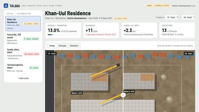
Talbai progress portal
Weekly drone flights turned into progress per building.
What people ask us.
Can you work with our existing ArcGIS?
Yes. We publish results into ArcGIS Online or ArcGIS Enterprise, or set up ArcGIS Enterprise for you on your own servers.
How accurate is it?
The imagery resolves 2–3 cm per pixel. Where you need survey-grade positions, we plan ground control points for the site before the flight.
What do we receive?
The orthomosaic and elevation model as standard GIS files, the extracted features as layers in your ArcGIS, and access to the portal.
How often should we fly?
It depends on how fast the site changes. Construction sites are often flown weekly or monthly; we agree the schedule for each site.
Priced per project or per site.
A fixed price for a defined survey or system, or a price per site for regular flights. Other ongoing work is billed by the hour.
Tell us what you're building.
We reply within one business day. Prefer email? Write to contact@primaroas.com.